 |
| Full view across the Nabesna Valley, from upper Trail Creek: a long, hard hike from the long, lonely road |
If the first trip to Wrangell-St. Elias National Park & Preserve seemed ambitious, the second was downright mad. To return, two weeks later -- the same 8 or 9 hour drive, this time splitting north at Glennallen to take the Tok Cutoff, turning into the park and following the Nabesna Road as far as we could go, then shouldering packs and fording creeks up to a pass high in the Mentasta Mountains (an eastern extension of the Alaska Range), while the forecast called for torrential rains followed by snow.
But backpacking! In Wrangell-St. Elias! (13.2 million acres, did I mention the thirteen point two million nearly-roadless, almost-entirely-trailless acres to explore?) It was my final weekend in Alaska. A friend and I had already shuffled work schedules, chosen a route (based more on its scenic beauty and potential wildlife-spottings than a do-able distance and elevation gain), and packed our gear. Neither of us had gotten in as much backpacking as we would have liked over the summer, and backcountry Wrangell-St. Elias was probably more than either of us should have tackled alone (I write, as though I'd actually wised-up after Gates of the Arctic) but, together, we felt eager and invincible. A little thing like a cold front wasn't going to deter us.
We headed off in time to drive up the sweeping Matanuska Valley before the gathering dusk transitioned wholly to darkness and rain began to fall in earnest. Near midnight, we began looking for a place to pitch our tents, choosing a seemingly-nondescript pull-out somewhere around Gakona. Rain and more rain, wind.
 |
| Copper River, Mt. Sanford (16,237 ft.) and Mt. Drum (12,010 ft) in the distance |
Then more of that Alaska magic, more of that unearned beauty: we woke to a view of the wide braids of the Copper River gleaming under a rain-cleansed, sun-bright sky, distant Mount Drum and Mount Sanford wrapped in residual clouds. The peaks accompanied us all the way to the park entrance. Buoyed by the break in the weather -- brisk temperatures but such unexpected sunshine! -- we practically danced into the Slana Ranger Station, only to be greeted with the news that the park had just suffered one of the worst rainstorms in recent memory; the Nabesna Road was washed out at mile 29 and the creeks were raging, perhaps impassable. No matter, we told the ranger, who looked skeptical but, to her credit, didn't try to dissuade us, We'll just see how far we get.
We didn't get far. Only a few miles down the road, I asked to pause for a photo -- snow-capped mountains rising above a spruce-studded bog, that miraculous blue sky overhead -- and stepped out of the car only to discover bushes dripping with fat, bright berries at my feet. What was meant to be a momentary stop turned into a half-hour feast as we grazed bear-like through blueberries and cranberries, noses dripping in the cold air, sun warm on our backs.
 |
| Still, Mt. Sanford, omnipresent |
By the time we returned to the car and continued down the road, fingers stained and hearts full, it was near noon. Still, no sense of urgency. We listened, rapt, to the NPS's narrated audio tour of the road, laughing as we tried to match the CD tracks with the mileposts. We gaped, amazed, at the distant Wrangells and nearby Mentastas, scouring the slopes of the latter for sheep. My friend dodged puddles, I read names from the map, and then there we were: mile 29, the road crumbling into a drainage. A truck was already idling, a group of guys unloading ATVs from its trailer. We parked, got out, and went to contemplate the crossing. Narrow -- only a few feet wide -- but equally deep, impossible for any car to navigate. The murky brown water looked fierce, forceful enough to continue gouging out the road; forceful enough to sweep us off our feet if we tried crossing it? We'll just see how far we get.
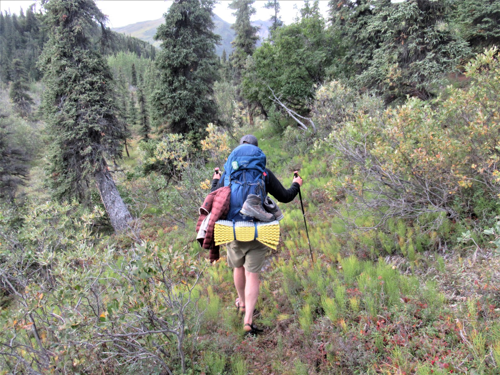
We didn't get far. After parking the car and catching rides across the drainage (courtesy of the amused ATVers), we found ourselves facing what turned out to be the rest of Trail Creek: a swollen series of braids, bursting free of any original channels, obliterating the road and weaving out of sight. Rather than try to ford them, we turned upstream, following the sound of the ATV engines in an attempt to locate the trailhead, which the map told us was on the far side of the creek. (Which one?) We crashed through brush and squelched through mud, splashed back and forth across what seemed like the central braid, still looking for the elusive trail. I soon rolled up my pant legs and swapped my boots out for sandals, figuring my feet were going to get wet no matter what; better save the boots. A good choice: when we finally located the muddy, rutted ATV trail, the whole thing was filled with flowing water -- so much water! Freezing water, but warming air, that sunshine! Numb toes, still a light heart; a building sense of hilarity. Should we turn around?, one of us would occasionally ask in desultory attempts to be a voice of reason. No, let's just see how far we get.
 |
| Still flooded two days later, though the water had receded several inches |
We didn't get far. The ATV trail periodically vanished; back to brush and mud. Trying to avoid the flooded lowlands -- how could there possibly be so much water? -- we scaled the riverbanks, only to be met with impenetrable vegetation, bogs, and, to our great delight and greater delay, patches of forest carpeted with more fresh berries. Again, we grazed and gorged, wholly aware that we weren't making any progress, but reveling in the experience. At one point, we popped out onto a gravel island, dropped our packs intending to grab a quick snack, and I actually fell asleep, sprawled out on a bed of sun-warmed, river-rounded rocks, lulled by the roar of raging water.
But then the temperature dropped. The sky filled with diaphanous clouds -- high, thin cirrus that set a halo around the sun and portended a shift in the weather. We consulted the map, only to realize that we'd barely made it two miles, at best. In three hours. We'd never make it up to the intended mountain pass and around to the neighboring drainage, Lost Creek. Who knows, Lost Creek might be even more flooded than this one. (The Slana ranger knew; she'd told us it would be worse.) Our feet were white with cold and bloody with scratches. Should we turn around? A little more hesitant, a little doubtful now: No, let's see how far we get.
 |
| One of the few walkable stretches: little brush, no running water. Even under the mildly improved conditions, hiking through brush in the Alaskan backcountry while wearing sandals and carrying a full pack is not ideal. |
Same refrain: not far. Still trying to stay away from the flooded creek, we found ourselves stranded in a swamp, scrambling over downed trees and leaping over deep pools, wearing sandals and carrying full packs. More brush, more bogs. We fought our way up onto a high ridge and, from there, again tried to gauge our progress: how little ground we'd covered, how far we had left to go before even reaching the foothills of the Mentastas. Thicker clouds were rolling in, quickly snuffing the early evening light. Feeling cold and defeated, I put my boots back on, Let's get a bit farther.
 |
| Overlooking the Nabesna Valley |
From there, we made a pointless detour up to an outcrop, just to see the spectacular view from its top: distant mountains, sweeping valley, thinning taiga, thicker clouds. We dropped down to the riverbed, only to re-discover the ATV trail and begin flying along, Mentastas nearing, tiny white dots of sheep scrambling along their slopes. Finally, worried about the increasing cold and imminent darkness, we chose a campsite on a gravel bar, exposed to bitter winds and in prime moose habitat, but the best we could do. As we ate dinner -- my friend waiting forever for his packaged kit to cook, me poking at tasteless leftovers -- the question arose again: Should we turn around?
Swallow. Consider. Shiver in the wind. Yes.
And, having conceded that the mountains and rivers and weather were too much for us -- that we would have to turn around, unable to do the loop we'd originally intended; that there was so much we wouldn't get to see -- the joy returned. Instead of feeling disappointed, a great weight lifted: there was no pressure, no need to do anything. This was our trip, this was wilderness-wandering. Unlike Gates of the Arctic, where I had to continue once I'd started, we had the freedom of going wherever we wanted, including back the way we'd come.
But first: Let's at least go see the pass.
 |
| Mt. Sanford, as seen from the foothills of the Mentasta mountains, thirty-odd miles away, as the raven flies |
We woke to snow the next morning. Laughing at the absurdity of our misadventure -- snow, in August! -- we packed up and headed off, soon to discover a random signpost telling us that we'd reached the end of the ATV trail. (More laughter -- what ATV trail?) Up and up, valley narrowing into jagged mountains etched with white. Even though the grade was steeper, it felt like we were practically floating (carefully) across the soft mosses and sedges, rather than breaking through brush or sinking into bogs. We covered the previous day's distance in half the time and were within sight of the pass by early afternoon.
 |
| Nearing the pass |
 |
| Nearer... |
 |
| The pass, right there! Right around the corner! |
There, the little demon of ambition (or obstinance) stirred in me: we were so close. If we pushed harder, we could make it all the way around, over the pass and down Lost Creek, fulfilling our original plan. True, that would be a much more challenging, riskier option: the maps told us Lost Creek passed through a tight gorge, already tough to navigate; what if it was totally flooded, truly impassable? What if we couldn't cross it, lower down? What if the brush that way was even worse? What if it started really snowing or, worse yet, sleeting? We were already in a somewhat inadvisable situation, having struggled to get this far; did we really have the strength and energy to make it the extra miles through wholly unknown terrain, with the weather deteriorating, rocks and bears and so much water?
Yes, my heart beat louder than my brain, Farther. If I'd been alone, I would have gone.
 |
| Even the pika knows it's a bad idea to go any farther. (Actually, it was just trying to blend in / pretending to be a rock.) |
Yet another reason not to hike alone: someone needs to rein in my irrational dreams.
My friend asked to eat lunch, so I had to stop. We huddled into a dip in the tundra, slightly sheltered from the wind and whirling snow. While he waited for his food to cook, I stared longingly at the pass, surrounding peaks disappearing into and reappearing out of the snow.
Mountains, no mountains, mountains.
Pass, no pass, pass.
Instead of feeling annoyed, the longer I sat, the more I felt my ambition -- and, with it, anxiety -- melt away. I spotted more sheep, and watched them flow along impossible cliffs. I studied the shapes and colors of nearby outcrops, and mentally traced them into my sketchbook. I felt the biting wind and listened to the howling silence and thought about all the wild places in the world and my great privilege to see some of them.
 |
| No mountains |
 |
| Mountains. And tundra. Glowing in brief sunshine. |
No pass. If I wanted, I could have stayed sitting there forever, watching the mountains, no mountains, mountains in the snow, occasional glimpses of blue sky, fleeting moments of sunglow.
It was enough. We had earned the beauty.


