Sunday, April 5, 2020

The beauty you *really* earn: Wrangell-St. Elias, part II


Full view across the Nabesna Valley, from upper Trail Creek: a long, hard hike from the long, lonely road

If the first trip to Wrangell-St. Elias National Park & Preserve seemed ambitious, the second was downright mad. To return, two weeks later -- the same 8 or 9 hour drive, this time splitting north at Glennallen to take the Tok Cutoff, turning into the park and following the Nabesna Road as far as we could go, then shouldering packs and fording creeks up to a pass high in the Mentasta Mountains (an eastern extension of the Alaska Range), while the forecast called for torrential rains followed by snow.

But backpacking! In Wrangell-St. Elias! (13.2 million acres, did I mention the thirteen point two million nearly-roadless, almost-entirely-trailless acres to explore?) It was my final weekend in Alaska. A friend and I had already shuffled work schedules, chosen a route (based more on its scenic beauty and potential wildlife-spottings than a do-able distance and elevation gain), and packed our gear. Neither of us had gotten in as much backpacking as we would have liked over the summer, and backcountry Wrangell-St. Elias was probably more than either of us should have tackled alone (I write, as though I'd actually wised-up after Gates of the Arctic) but, together, we felt eager and invincible. A little thing like a cold front wasn't going to deter us.

We headed off in time to drive up the sweeping Matanuska Valley before the gathering dusk transitioned wholly to darkness and rain began to fall in earnest. Near midnight, we began looking for a place to pitch our tents, choosing a seemingly-nondescript pull-out somewhere around Gakona. Rain and more rain, wind.

Copper River, Mt. Sanford (16,237 ft.) and Mt. Drum (12,010 ft) in the distance

Then more of that Alaska magic, more of that unearned beauty: we woke to a view of the wide braids of the Copper River gleaming under a rain-cleansed, sun-bright sky, distant Mount Drum and Mount Sanford wrapped in residual clouds. The peaks accompanied us all the way to the park entrance. Buoyed by the break in the weather -- brisk temperatures but such unexpected sunshine! -- we practically danced into the Slana Ranger Station, only to be greeted with the news that the park had just suffered one of the worst rainstorms in recent memory; the Nabesna Road was washed out at mile 29 and the creeks were raging, perhaps impassable. No matter, we told the ranger, who looked skeptical but, to her credit, didn't try to dissuade us, We'll just see how far we get.

We didn't get far. Only a few miles down the road, I asked to pause for a photo -- snow-capped mountains rising above a spruce-studded bog, that miraculous blue sky overhead -- and stepped out of the car only to discover bushes dripping with fat, bright berries at my feet. What was meant to be a momentary stop turned into a half-hour feast as we grazed bear-like through blueberries and cranberries, noses dripping in the cold air, sun warm on our backs.

Still, Mt. Sanford, omnipresent

By the time we returned to the car and continued down the road, fingers stained and hearts full, it was near noon. Still, no sense of urgency. We listened, rapt, to the NPS's narrated audio tour of the road, laughing as we tried to match the CD tracks with the mileposts. We gaped, amazed, at the distant Wrangells and nearby Mentastas, scouring the slopes of the latter for sheep. My friend dodged puddles, I read names from the map, and then there we were: mile 29, the road crumbling into a drainage. A truck was already idling, a group of guys unloading ATVs from its trailer. We parked, got out, and went to contemplate the crossing. Narrow -- only a few feet wide -- but equally deep, impossible for any car to navigate. The murky brown water looked fierce, forceful enough to continue gouging out the road; forceful enough to sweep us off our feet if we tried crossing it? We'll just see how far we get.

We didn't get far. After parking the car and catching rides across the drainage (courtesy of the amused ATVers), we found ourselves facing what turned out to be the rest of Trail Creek: a swollen series of braids, bursting free of any original channels, obliterating the road and weaving out of sight. Rather than try to ford them, we turned upstream, following the sound of the ATV engines in an attempt to locate the trailhead, which the map told us was on the far side of the creek. (Which one?) We crashed through brush and squelched through mud, splashed back and forth across what seemed like the central braid, still looking for the elusive trail. I soon rolled up my pant legs and swapped my boots out for sandals, figuring my feet were going to get wet no matter what; better save the boots. A good choice: when we finally located the muddy, rutted ATV trail, the whole thing was filled with flowing water -- so much water! Freezing water, but warming air, that sunshine! Numb toes, still a light heart; a building sense of hilarity. Should we turn around?, one of us would occasionally ask in desultory attempts to be a voice of reason. No, let's just see how far we get.


Still flooded two days later, though the water had receded several inches

We didn't get far. The ATV trail periodically vanished; back to brush and mud. Trying to avoid the flooded lowlands -- how could there possibly be so much water? -- we scaled the riverbanks, only to be met with impenetrable vegetation, bogs, and, to our great delight and greater delay, patches of forest carpeted with more fresh berries. Again, we grazed and gorged, wholly aware that we weren't making any progress, but reveling in the experience. At one point, we popped out onto a gravel island, dropped our packs intending to grab a quick snack, and I actually fell asleep, sprawled out on a bed of sun-warmed, river-rounded rocks, lulled by the roar of raging water.

But then the temperature dropped. The sky filled with diaphanous clouds -- high, thin cirrus that set a halo around the sun and portended a shift in the weather. We consulted the map, only to realize that we'd barely made it two miles, at best. In three hours. We'd never make it up to the intended mountain pass and around to the neighboring drainage, Lost Creek. Who knows, Lost Creek might be even more flooded than this one. (The Slana ranger knew; she'd told us it would be worse.) Our feet were white with cold and bloody with scratches. Should we turn around? A little more hesitant, a little doubtful now: No, let's see how far we get.
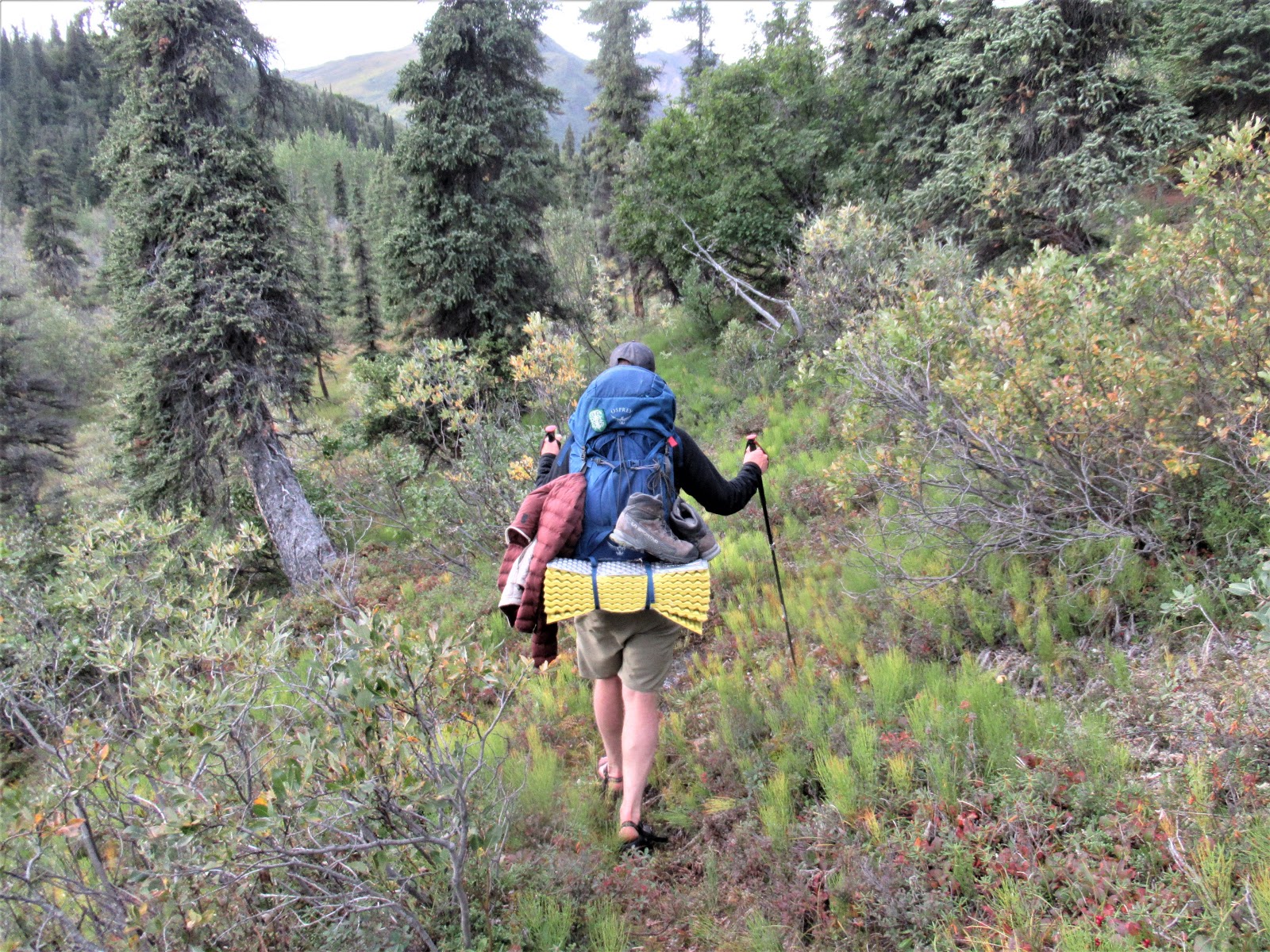

One of the few walkable stretches: little brush, no running water. Even under the mildly improved conditions, hiking through brush in the Alaskan backcountry while wearing sandals and carrying a full pack is not ideal.

Same refrain: not far. Still trying to stay away from the flooded creek, we found ourselves stranded in a swamp, scrambling over downed trees and leaping over deep pools, wearing sandals and carrying full packs. More brush, more bogs. We fought our way up onto a high ridge and, from there, again tried to gauge our progress: how little ground we'd covered, how far we had left to go before even reaching the foothills of the Mentastas. Thicker clouds were rolling in, quickly snuffing the early evening light. Feeling cold and defeated, I put my boots back on, Let's get a bit farther.

Overlooking the Nabesna Valley

From there, we made a pointless detour up to an outcrop, just to see the spectacular view from its top: distant mountains, sweeping valley, thinning taiga, thicker clouds. We dropped down to the riverbed, only to re-discover the ATV trail and begin flying along, Mentastas nearing, tiny white dots of sheep scrambling along their slopes. Finally, worried about the increasing cold and imminent darkness, we chose a campsite on a gravel bar, exposed to bitter winds and in prime moose habitat, but the best we could do. As we ate dinner -- my friend waiting forever for his packaged kit to cook, me poking at tasteless leftovers -- the question arose again: Should we turn around?

Swallow. Consider. Shiver in the wind. Yes.

And, having conceded that the mountains and rivers and weather were too much for us -- that we would have to turn around, unable to do the loop we'd originally intended; that there was so much we wouldn't get to see -- the joy returned. Instead of feeling disappointed, a great weight lifted: there was no pressure, no need to do anything. This was our trip, this was wilderness-wandering. Unlike Gates of the Arctic, where I had to continue once I'd started, we had the freedom of going wherever we wanted, including back the way we'd come.

But first: Let's at least go see the pass.


Mt. Sanford, as seen from the foothills of the Mentasta mountains, thirty-odd miles away, as the raven flies

We woke to snow the next morning. Laughing at the absurdity of our misadventure -- snow, in August! -- we packed up and headed off, soon to discover a random signpost telling us that we'd reached the end of the ATV trail. (More laughter -- what ATV trail?) Up and up, valley narrowing into jagged mountains etched with white. Even though the grade was steeper, it felt like we were practically floating (carefully) across the soft mosses and sedges, rather than breaking through brush or sinking into bogs. We covered the previous day's distance in half the time and were within sight of the pass by early afternoon.

Nearing the pass

Nearer...

The pass, right there! Right around the corner!

There, the little demon of ambition (or obstinance) stirred in me: we were so close. If we pushed harder, we could make it all the way around, over the pass and down Lost Creek, fulfilling our original plan. True, that would be a much more challenging, riskier option: the maps told us Lost Creek passed through a tight gorge, already tough to navigate; what if it was totally flooded, truly impassable? What if we couldn't cross it, lower down? What if the brush that way was even worse? What if it started really snowing or, worse yet, sleeting? We were already in a somewhat inadvisable situation, having struggled to get this far; did we really have the strength and energy to make it the extra miles through wholly unknown terrain, with the weather deteriorating, rocks and bears and so much water?

Yes, my heart beat louder than my brain, Farther. If I'd been alone, I would have gone.

Even the pika knows it's a bad idea to go any farther. (Actually, it was just trying to blend in / pretending to be a rock.)

Yet another reason not to hike alone: someone needs to rein in my irrational dreams.

My friend asked to eat lunch, so I had to stop. We huddled into a dip in the tundra, slightly sheltered from the wind and whirling snow. While he waited for his food to cook, I stared longingly at the pass, surrounding peaks disappearing into and reappearing out of the snow.

Mountains, no mountains, mountains.

Pass, no pass, pass.

Instead of feeling annoyed, the longer I sat, the more I felt my ambition -- and, with it, anxiety -- melt away. I spotted more sheep, and watched them flow along impossible cliffs. I studied the shapes and colors of nearby outcrops, and mentally traced them into my sketchbook. I felt the biting wind and listened to the howling silence and thought about all the wild places in the world and my great privilege to see some of them.

No mountains

Mountains. And tundra. Glowing in brief sunshine.

No pass. If I wanted, I could have stayed sitting there forever, watching the mountains, no mountains, mountains in the snow, occasional glimpses of blue sky, fleeting moments of sunglow.

It was enough. We had earned the beauty.


Saturday, February 22, 2020

And then there's the beauty you earn

On Root Glacier, looking toward Bonanza Ridge and Porphyry Peak
Wrangell-St. Elias National Park and Preserve, AK

13.2 million acres. Thirteen-point-two million acres. The largest unit managed by the National Park Service, equal to two Adirondack Parks, or six Yellowstones. Of those 13.2 million acres, 9 million acres of designated Wilderness. The country's largest wilderness area, big enough to swallow three each of Yosemite, Boundary Waters, and the Bob.

Superlatives continue: St. Elias, the fourth-highest mountain in North America, rising to 18,008 feet only ten miles away from the ocean. Bona, the highest volcano in the country and Wrangell, one of the most massive active volcanoes in the world. The continent's largest subpolar icefield (Bagley), longest valley and tidewater glaciers (Nabesna and Hubbard), and watershed that drains into two of the largest rivers (by discharge): the Yukon and the Copper.

Rock, ice, and water; tundra, forest, and wetland. Wolves and wolverines. Bears, both brown and black. Dall sheep, caribou, moose, marmot, pika. Ptarmigan, terns, golden and bald eagles. That 13.2 million acres of space through which they roam.

If there is such a thing as true wilderness left in the world -- an unfathomably large area, dominated by natural forces and inhabited by creatures that may live out their lives without ever encountering any sign of man -- it's here, in Wrangell-St. Elias National Park & Preserve.

Into this huge swath of mountains and rivers and ice cut two lonely roads, accessing merely the northwestern quarter of the park. Narrow ribbons of gravel and dirt, rutted and potholed, overgrown with shrubbery in some sections and overrun by hares in others. The roads are as wild as the terrain they try to breach: the 59-mile-long McCarthy Road gave my friend's Jeep a flat tire, and the 42-mile-long Nabesna Road was washed out at mile 30. "Driving the Nabesna Road can be an adventure," the NPS audio guide both warns and promises, "Have fun and take it slow. Soak it in. Pull over. Step out of your vehicle and take a deep breath of the Alaskan air. Drink in the beauty."

Beauty, indeed. But the sort of beauty you have to earn.

Wave of ice on Root Glacier

#

The scenery in Chugach National Forest -- particularly, Portage Valley -- is undeniably spectacular. Awe-inspiring. Photogenic. Popular, and popular for a reason. I loved working there and am excited to return this summer -- to again step out the door into a world rich with mist and midnight sun. Bears, berries, salmon. Snow-capped peaks and that impossibly blue glacial ice. My packraft is eager to go bobbing back down Portage Creek, my XTRATUFs ready to splash along the Trail of Blue Ice. This summer, I promise myself, I'll camp out more; I'll get out on Prince William Sound; maybe I'll finally try bushwhacking up Byers or Begich. I'll continue to walk and walk and walk, 4 a.m. dawn until 12 a.m. dusk.

And I'll return to Wrangell-St. Elias.

Early evening shadows on Root Glacier and Donoho Peak

#

It seemed like an ambitious plan, for my friend and I to squeeze in a trip to Kennecott over a long weekend last August. At least 8 hours of driving, each way (not accounting for the condition of the McCarthy Road), plus another hour or two to catch a shuttle down the 5 miles beyond the Kennecott River footbridge. A 2 mile hike to Root Glacier, lugging in all our water and supplies, hoping that a campsite would be free, that bears would stay away, and that the groups on the trail were just there for the day, leaving us with peace and quiet and an enormous confluence of ice and rock all to ourselves overnight. This dream in mind, we rearranged work schedules, ordered a set of crampons each, packed food, and watched as weather forecasts alternated between sun and rain.

The day came. We headed off after work: Anchorage, Palmer, the winding scenic drive down the Matanuska River valley (which, I realized, I'd longed to see seven years earlier, as I passed by en route to Denali). The Matanuska Glacier, glowing as the sky dimmed toward night. Glennallen and Copper Center in the dark, marveling at how long it took for the stars to appear. After turning into the park and catching a few hours' sleep, we woke groggily to the sight of the Copper and Chitina Rivers, gleaming silvery-bronze with pre-dawn light.

Silvery braids of the Chitina River

Wrangell-St. Elias! We were in Wrangell-St. Elias! As my friend navigated the road's potholes and hares, I promptly fell back asleep, occasionally opening my eyes to see dream-like scenes of distant mountains, spindly spruce, ducks paddling through mirror-calm ponds, and old railroad bridges soaring over narrow chasms. Then we were in McCarthy, streaming with sunshine; Kennecott, with its half-restored rickety red mine buildings clustering up a hillside; on the trail, realizing that the odd shapes far down the valley weren't weirdly-shadowed clouds, but the slopes of Mt. Blackburn, stretching 16,390 feet into the sky. First glimpses of Kennecott and Root Glaciers: the long, wide former piled with rocky debris (supraglacial moraines), but the latter -- a tributary -- shiny white before the confluence.

Somewhere between awake and dreaming, along McCarthy Road

Kennecott Mines National Historic Landmark, with Donoho Peak in the background

Trail alongside Kennecott Glacier (coated with lumps of glacial debris), with the white tongue of Root Glacier flowing in from the right. Donoho Peak straight ahead, Blackburn hiding far behind and high above it

A glacier! I'd managed to touch Portage earlier in the season, but had never actually set foot on much less wandered freely across the surface of a glacier before. While my friend chose to rest in the luxurious early-evening sunlight and the last of the day-hikers were departing, I dashed off to clamber and slide around the hard, smooth, blindingly-bright ice. Every new marvel set me giggling with delight: the scraping sound of the crampons, the crunch on softer surfaces; the striations and waves and supraglacial streams, how the whole mass appeared to move even as it stood grindingly still; the light, tilting farther into evening, filling the glacier and surrounding mountains with blue shadows. Blackburn, to the distant northwest, still wrapped in cloud, and, straight north, Stairway Icefall, a 6300-foot wall of broken ice. ("Stairway to Heaven Icefall", the USGS had proposed calling it in 1965. Whoever it was at the Board on Geographic Names that insisted on cutting the "to Heaven" part clearly never saw the feature in person.)

All that space and wildness, well worth the effort it had taken to get there.

Stairway [to Heaven] Icefall, churning into Root Glacier. Regal Mountain (13,845 ft) up there somewhere, tucked behind numerous 11,000-12,000 ft. prominences, unnamed on the map

I woke early the next morning and headed off to traverse a "trail" along the slopes above Root Glacier, following it until it disappeared on a narrow, steep-sided lateral moraine, which happened to coincide with the place where a bear was ambling down the mountainside toward me. Returning to our campsite, I met my friend and we headed out onto the glacier, which was even brighter in the midday sunshine. Again, it was all giggles, all delight, doubly so with two of us to see and celebrate the marvels. A waterfall! A crevasse! Seracs smoothed by sinuous streams, slot canyons between walls of ice. What looked like a flat white surface from a distance was in fact a wonderland of shapes, textures, and colors. A playground, for us and for the dozens of day-visitors, who were, by mid-afternoon, tromping along behind guides, seeking scenic meltpools and scaling icy cliffs. Plenty of space and wildness for us all to enjoy.


Crevasse, Root Glacier

When I returned to the glacier again after dinner, 8 or 9 p.m. -- the light quiet and the shadows deep, the world empty -- I had that space and wildness all to myself. After scaling the by-then familiar access point, I meandered vaguely north and west, both lured onward and constrained by the topography of the ice. By that point, I was done giggling at every new experience and on to simply marveling -- the power, the grace, the scale of this geologic force; the sheer beauty of this place. As the sun dipped low and the sky flared with blues, violets, and pinks, I stood by the edge of a meltpool and watched the ice change colors, too -- blues, violets, and pinks, not just reflected from overhead, but absorbed and re-emitted with a cold, glacial glint. The colors lingered well into twilight, as did I.

Not the sort of beauty that shows up in a photo. Not the sort of beauty that can be seen via tourboat or tourbus, nor felt on a short walk. The sort of beauty you earn.

Last of the sunlight, snagging on and in the ice

#

And that's just the first of my adventures in Wrangell-St. Elias. More to come, 13.1999 million acres left to explore...


Sunday, June 2, 2019

First views, Chugach National Forest

Icebergs, Portage Lake

This place—a narrow strip of land stretching from Prince William Sound to Turnagain Arm; a deep valley separating the Kenai Peninsula from the Chugach Range; a not-so-secret corner of south-central Alaska—is dripping with beauty. The mist-swirling, water-falling, mountain-brooding, glacier-blue-ing, iceberg-floating, flower-blooming, bear-scatting, eagle-soaring, eye-popping, jaw-dropping kind of beauty that assaults one’s senses and overwhelms one’s soul. Round a corner and there’s a thousand-foot cascade; look up and an arete pierces the clouds; pause a second and a skein of snow geese honks overhead; inhale and your lungs fill with the fresh scent of willows. Pine. Rain. Rock. Ice. Beauty, beauty everywhere.

Temperate rainforest

Waterfalls streaming off of Maynard Mountain

Barrow's Goldeneyes

It’s too easy.

As I write, it’s 11 p.m. at 60 degrees north latitude, late May.  The sky glows with the diffuse light of rainy dusk. A carpet of moss and lichen erupts in wildflowers. Small shrubs shiver in the wind. Out one window, a ribbon of water shimmers down a dark ravine; out another, snow-covered mountainsides blend into stormclouds. Through that same window this morning, I watched a big fluffy black bear amble by, pausing to gauge his surroundings, nose twitching with curiosity. I didn’t even have to stand up; the wild beauty came to me.


Morning visitor, as seen through the kitchen window

Sunrise, Portage Lake (first clear morning)

It’s too easy.

Within a five-minute walk, I can be on the shore of a deep, glacially-carved and -fed lake. The water is surely grey and choppy right now, with little icebergs and bergy bits bobbing up and down. After the storm passes (and if there’s a rare window of calm before the next rolls in), those chunks of ex-glacier will linger by the shoreline, suspended in the reflection of the surrounding mountains, serenely glowing their impossibly blue blue. Mist will hover over the peaks and ride katabatic winds down the valleys, making it impossible tell what’s rock and what’s air. Gulls will soar overhead, their screams ringing into the silence. Beautiful.

Mist over Portage Lake, weaving past the remnants of an iceberg

It’s too easy.

When I think of the most awe-inspiring landscapes I’ve seen—the colorful clay hills of Arizona’s Painted Desert; the snow-swept ridges of southwestern Wyoming; the remoted ravines in Colorado’s Black Canyon; the sheer expanse and even more expansive, unreadable sky of Alaska’s North Slope—I think of them not as vistas or scenery, but as experiences. I had to earn them. Years prowling the Painted Desert. Frost-nippingly cold moon-lit mornings in Wyoming. Long, arduous treks scaling fossiliferous outcrops. Nearly two weeks of whirling down little-travelled rivers in a tiny red raft, ignorant and open to any and all topographical, hydrological, and meteorological challenges (and hyper-aware of the possibility of polar bears). The arduousness and uncertainty heightened my senses, and thus left me even more attuned to beauty. Richer, deeper, hard-won beauty.

(A counter-point to ponder: the view from the Arctic Divide at the heart of the Brooks Range was awe-inspiring and life-changing, but I was too terrified and exhausted to appreciate it. It was too hard.)

Portage Glacier

Here, in this place, where beauty is so easy, does it count to just look up? To stop by in a car or bus en route to or from Anchorage or Whittier? To hop out at the lake to snap a photo or spend an hour strolling one of the trails? To ride out to the foot of the glacier—to face the wall of blue ice, to float with the bergs, to hear waterfall after waterfall splashing off of the cliffsides, all from the comfort and safety of a large tourboat piloted by someone else?

Hundreds or thousands of people come to witness this scenery each day. Surely, it makes us momentarily happy. It enriches our lives to see it, to know it’s there. But if all we have to do is look, do we bother to feel more deeply? Do we care to learn the underlying processes and meanings?

What’s hidden out there, bigger, wilder, beyond beauty?


Saturday, August 25, 2018

Gates of the Arctic III (a.k.a. place-remembering)


"The storm was swinging eastward...[T]he sun was shining brilliantly on countless lofty peaks without name and beyond the scope of human knowledge. All around [me] were gorges, thousands of feet deep, great snowbanks, bright green valleys, gaily colored rocks. All was peace and strength and immensity and coordination and freedom" — Bob Marshall, Alaska Wilderness

Water, rock, snow, moss, sedge, sky, fog, and my feet—that was my world, for 11 days. Seventy-odd miles through the Brooks Range along what, retrospectively, was a poorly-chosen route from the Dalton Highway to Anaktuvuk Pass. A million dangers and me trying to navigate them, alone.

Terrifying. Affirming. Elemental.

Frigid shooting stars bobbing in mid-morning light, Itkillik Valley

No, there was more than that. There were flowers—everywhere I stepped, colorful, delicate little Arctic blooms. Fuchsia-colored frigid shooting-stars rising up and arcing bashfully back down. Creamy bell-heather ringing out across entire hillsides. Tall, pink-stemmed wintergreen boasting a dozen greenish-white blossoms. Blue-purple narrow-leaved gentians barely beginning to bud. Bright yellow Arctic poppies eagerly following the summer sun as it circumambulated the sky. Dozens of species, hundreds of thousands of individual plants. How many did I crush underfoot, just trying to keep trudging, to make it across the ridges and through the ravines?

Woolly lousewort and mountain avens overlooking Limestack Mountain

And there were animals. Every now and then, I registered the anxious chirping of ground squirrels or anxious cheeping of, um, black-bellied plovers? (I’m not very good at bird identification, especially when I’m tired and hungry and want nothing more than to not be where I am.) Snipes sniped from the marshes. Ravens laughed from the ridges. A couple of moose loped languidly through the same stretch of sedges and brush that had taken me a full day to fight through. Surely, bears and wolves were watching, waiting to pounce; they’d left their pawprints everywhere, signs telling interlopers to be wary, be aware.
Black-bellied plover?

And of course there were rocks (usually my favorite part of a place, other than the clouds). Thick ledges of limestone, glinting scarps of schist, great cobbles of conglomerate, stacked on top of one another at precarious angles with dubious stability. The mountains only pretended to be solid, intact, timeless; erosion was the true master here. I lost count of the number of fresh-looking talus-fields I had to negotiate, much less the frequency with which boulders shifted underfoot. Riverbanks gave way. Rockfalls reverberated through rain and mist. One afternoon, without warning--crash...crashcrashcrash whoosh; a chunk of mountainside gave way, just across the Itkillik River from me. (I wasn't comfortable with that distance. Elsewhere on the Itkillik, at some point within the last decade or so, judging from the vegetative regrowth, half of a peak rising 3,000 feet directly up had slid off and crashed all the way down to the other side of the valley, damming the river and leaving great piles of debris. The scar is so enormous that it’s visible from satellite imagery on Google maps.)


Massive debris slide, west of Oolah Pass

Other than that, there were bogs. Meadows. Hidden pools and rivulets. Perilously steep mountain “passes”. Waist-deep rivers considered mere side drainages, not even worth a name on the maps. Add to that the wind, the rain, the ice and snow. The mosquitoes.

Good god, the mosquitoes.

That’s what I went for, no? To feel tired and cold and hungry and afraid. To feel grateful for little miracles—a break in the clouds or a stretch of solid ground. To soak in the silence. (There was never any silence. Water, always running water, usually wind, and those rockfalls.) To live consciously, putting effort into every step. (Just getting water was an ordeal: paying attention to when the bottle was running low, keeping an eye out for an appropriate stream—deep enough, not too deep; clear, not silty or sandy; with enough of an accessible bank; preferably, little vegetation around and thus lower concern for bears or moose—taking off the pack, getting out the pump, assembling the pump, being careful not to let the clean hose get in the water, pumping, being careful not to tip the water bottle, careful again with the clean hose while disassembling the pump, repacking, and—the hardest part of the whole ordeal—convincing myself to heft that awful pack back on again and continuing.) 

To be self-sufficient, comfortable with silence and self and that huge, wild world.

Alone in a tent, waiting out the rain and ice near the very headwaters to the North Fork of the Koyukuk; preparing to cross the Arctic Divide; wondering why on earth I'd chosen to do this, what I'd hoped to find

Traveling alone, I had to be self-sufficient. If I wanted a sip of water, I couldn’t just ask someone to please grab my water bottle; I had to stop, take off the pack. If my stove was slightly temperamental, I couldn’t just borrow someone else’s. If I wasn’t sure where I was, I couldn’t pore over the maps with another set of eyes. If I wasn’t sure whether a river was safe to cross, I couldn’t talk it over with someone else. I had to pace back and forth along the bank for a while, plunge in, sometimes retreat, then plunge back in again, knowing that I had to get across, even if the current was stronger than me.

(Swollen with rain and turbid with silt, the rivers were so very, very much stronger than me. But I had to cross them. Alone.)

Rain, rain, rain = raging rivers, soggy tundra, tendrils of mist

On the plus side, no one else was around to watch me crawl up onto a bank, post-river-crossing, and lie on the mud and rocks, sobbing with terror and gratitude. No one saw me swing my trekking poles wildly through the air, swatting and swearing at mosquitoes. No one could tell me that I was an idiot for crossing the dangerously steep snowbank, or laugh when I fell in the bog. Or laugh even harder when I fell in the same bog again. No one made me get out of my cozy tent, pack up, and start hiking when it was cold and rainy out. Instead, I was responsible for making myself do that.

The best part was getting to stop whenever and wherever I wanted, then getting to stay put for as long as I wanted (or until I finished off my daily ration of m&ms). In general, I hit a routine of hiking for 40 minutes and resting for 20, but I also had some luxuriously long tundra naps, nestled into a warm carpet of lichens, mosses, and tiny shrubs. It was nearly as blissful to snuggle into my sleeping bag at night, feeling warm and safe against the rain and hail and wind outside. One long hazy evening--the only cloud-free stretch of the whole trip--I chose not to put the rainfly on my tent so that I could wake periodically to see the deep pink orb of the sun circumambulating the wide headwaters of the Anaktuvuk River, painting snowcapped mountains in fluorescent hues.

"Night", Anaktuvuk Valley. Numinous.

****

Bob Marshall’s Alaska Wilderness was all celebration, all beauty and exhilaration. Euphoria, not fear of rockslides, not a stream-crossing every hour; no mention of him waking at 2 a.m. in the middle of a cold downpour with an urgently full bladder. Sure, some tussocks; sure, nearly getting swept down a few rivers. But bears? Shoot ‘em. Mountains? Climb ‘em. Sixty-five pound packs? All the more enjoyable. He made his mishaps sound fun, part of the grand adventure.

Retrospectively, I had fun, too. Certainly a grand adventure. But only because I survived. I went looking for the wildest of wildernesses, for beauty and meaning in the non-human world, but in the moment, in the place--over the passes, through the rivers, around the tussocks, across the snow, past however many bears that looked like boulders in the mist--what I cared about most was surviving, one foot in front of the other.

How wonderful, to be alive. And even more wonderful, to be alive in a world where a place like Gates of the Arctic still exists. Not just names in a book or squiggles on a topographic map, but a real place, a raw place, the ruggedy-est of ruggedy places, all immensity and freedom.

Arctic Divide at Peregrine Pass, looking toward Als Mountain. I think Al Retzlaf and Bob Marshall would be pleased to know that this place, which they first explored nearly eighty years ago, is still just as wild. 

Saturday, August 18, 2018

Gates of the Arctic II (a.k.a. place-experiencing)


[T]o [a human being] just back from the source streams of the Koyukuk, no comfort, no security, no invention, no brilliant thought which the modern world had to offer could provide half the elation of the days spent in the little-explored, uninhabited world of the arctic wilderness -- Bob Marshall, Alaska Wilderness

(The following are excerpts from my field notebook / raw data from my grand experiment to experience Marshall's "Alaska Wilderness", now protected as Gates of the Arctic National Park and Preserve)

Oolah Pass, just before the storm breaks
Evening, Day 2, in the middle of an early-July hailstorm, hoping the tent will hold
How am I ever going to be able to lug this pack for ten more days, over more passes and through more rivers?
Good god, the rivers.
I'll never make it [on a solo traverse of part of the Brooks Range, from the Dalton Highway to the village of Anaktuvuk Pass]. Bigger, harder than I remembered or expected, how could I have ever thought this possible, much less necessary?
Why am I doing this?

[An hour later, the sun came out. I emerged from the tent for a hasty dinner between storms. Freezing cold, but fierce, beautiful, blazing.]


****
Afternoon, Day 3, having just (barely) made it across the turbid blue-grey rapids of the rain- and snowmelt-swollen Itkillik River, then crawled out onto the bank and sobbed until my heart stopped fluttering and stomach unknotted
I do NOT want to be here, do NOT want to be doing this, what on earth do I think I'm doing? Why?

[An hour later, curled up under my poncho to wait out another bout of rain and watch as the rest of the valley disappeared then reappeared under a glorious full rainbow, unexpectedly, the sky broke open to a pure Arctic blue.]

****
Midday, Day 5, having fallen in a creek, slipped again on wet mossy rocks, begun to shiver uncontrollably in the pouring rain, pitched the tent early and crawled into my sleeping bag for what would be a very long tent-bound afternoon / night, time punctuated only by the echoing crash of ice and rock falling off the cliffs on the other side of the valley
Nearly 24 hours feeling cold, lonely, and afraid in a tent at the headwaters of the North Fork of the Koyukuk. But pure wildness.
What am I doing here? What brought me here? What had I hoped to find? And why is so much beauty, so much wildness only making me feel cold, tired, in pain? Where's the wonder, the joy, the sublime?
Nothing but dread for tomorrow (good god, Peregrine Pass), and the next day, and the next.
How I wish I had a warmer hat. A dry suit. A GPS. How I wish I wasn't here, that I hadn't come. I wish life had worked out so I wouldn't have felt whatever it was that made me think I needed to come.
How I wish it would stop raining.
[The next morning: woke to ice on the tent and a glorious fog-bow.]

****
Evening, Day 6, while eating dinner under a sky rippling and roiling with clouds
What am I doing out here, so far and so alone?
Asperitas. NOT the clouds you want to see on day 6 of an 11 day wilderness trip, dozens of mountain-toothed, river-laced, and bog-riddled miles from any semblance of civilization.  But breathtaking.

****
Midday, Day 7, during a luxuriously long tundra nap
To be honest, I don't even care.
I'm sure it's beautiful—the photographs will attest to that, belatedly—but right now, I have neither the energy nor the inclination to appreciate it. In fact, except when I stop to unstrap my ungodly heavy pack and collapse down to rest, sprawling across the tundra, I can’t look up and drink in the scenery -- the soaring mountains, the sweeping valleys, the churning layers of sky. All of my attention has to be on the ground. Step by every single step, I have to focus on my feet, never sure whether I’ll sink knee-deep in wet moss, tilt sideways off a tussock of grass, slip into an icy-cold stream, or jiggle a rock in just the wrong way and send a whole mountainside of scree tumbling down the precipitous slope I'm gingerly trying to traverse. 

And yet, lying here, nestled into the soft (lumpy, wet) mosses and sedges, mosquitoes feebly failing to get through the headnet, sun weakly trying to shine, well: This is bliss.
Ernie Pass. I could have stayed here forever

****
Evening, Day 9, sitting on a hillside eating dinner as moose go browsing by and a rainbow arcs off to the east, a worthwhile end to an otherwise miserable day
Nearly got swept away by what was supposed to be an unnamed side drainage--an opaque brown mass at least a foot higher than usual, judging from how it swallowed shrubs and branches along the shore.
Should have waited. Shouldn't have crossed where I did--just one wide channel, thigh-deep, no respite. Legs weak, weaker, right calf popped halfway across. I had to stop, lean in, pray that the rocks wouldn't shift under my feet and that I'd still be able to walk. Inch by inch, numb with cold and absolute fear by the time the water shallowed to knee-deep. Just when I thought it was over, proceeded to slip on the mud-coated bank, fall in the river, soaked.
Tomorrow: another drainage, with an even larger watershed than this one. I'm really not sure I can make it. But I have to. I don't have any idea why I came here, but since I did, I now have to keep going, somehow.
Won't it ever stop raining? Mist ever stop swirling? What happened to Marshall's promise of mountains that are sharp and absolute?

****
Afternoon, Day 10, having summoned all of my willpower and then some to pack up and march toward the drainage, against absolute dread
Miserable, cold, wet, far edge of exhausted. But across.
Rain, mosquitoes, bogs. Freeing, to not care about wet feet any more.

****
Morning, Day 11, still in tent. Crying, if only to keep warm
Really, world? Really?
Fog. All fog. Can't see a thing. No idea which way to go. Map and compass are useless when the world is invisible. Yet again, what was I thinking, to refuse to bring a GPS? Idiotic wilderness purist idealism. Amaze me, wilderness!, I ask; I came to you alone, over-laden yet under-equipped. Humbled, open. Yet I demand, Give me hope, meaning, joy!
In reply, fog.

Stumbling blindly through nothingness for several hours, navigating by the sound of airplane engines echoing out from Anaktuvuk Pass, my dubious sense of direction, and a mix of stubbornness, desperation, and raw hope. Apparently, that's all I needed.


Monday, June 4, 2018

Gates of the Arctic I (a.k.a. place-dreaming)


This is how it begins: with the name of a place, boxed off on a map. A distant place, a wild place, a place that seems more mythical than real. “Gates of the Arctic,” this place is called, as if a portal to another world.

Then the idea—impossible! Absurd!—to visit that place. To see the mountains, to ford the rivers, to fight the tussocks. (To stay far, far away from the bears.)

Wholly impossible? Entirely absurd?

The dream begins to take shape. You study the maps more carefully. There are airports, roads, your own two feet. Oolah Pass, Peregrine Pass, Ernie Pass. Anaktuvuk, Naqsraq, a pass, a river, a “place with no mountain” nestled in the heart of the Brooks Range, opening to the vast North Slope. You can envision yourself climbing the ridges and camping by the creeks. Mile after mile of tundra and rocks; day after day of rain, snow, ice. Mosquitoes. That glorious midsummer light.

Before long, it doesn’t just seem possible, but necessary. Yes, you must visit this place, you need to feel the cold pull of the rivers, the cold push of the rain. You need to spend a week or more alone with the caribou and the wolves. More than anything, you need the 7.2 million acres of wilderness through which they roam.

A different sub-Arctic wilderness--the Alaska Range, Denali National Park

You’re not sure why you need this place—what is it you seek there? What is it you’ll find? It’s a pilgrimage without a destination, a quest without a task. It’s a Snow Leopard without a Crystal Monastery. And without a snow leopard, for that matter. (“Have you seen the snow leopard?” asks Peter Matthiessen, “No! Isn’t that wonderful?”) It’s a Mount Analogue without a ship or a crew. (“And you, what are you looking for?” was to be the last chapter of Rene Daumal’s allegory.) It’s not at all an Into the Wild. (Dangerous, yes, but not foolhardy, not reckless. You’ll bring maps and food; you'll follow all Leave No Trace principles; you’ve backpacked in Alaska before, just not this far north, this big, alone.)

Maybe you're just trying to escape from your daily routine, to find something more pressing and real than your life of quiet desperation. Rather than sitting here comfortably under a sturdy roof, you'd prefer to be out there, packing up a tent in the pouring rain. You'd rather be crossing a river vs. crossing the street. Facing bears vs. watching squirrels. Eating oatmeal, more oatmeal, only oatmeal vs. frying eggs and bacon. You know you’ll later regret saying it, but--you claim now--you’d rather be walking over tussocks than skipping down sidewalks. (You've never fared well in places with sidewalks.)

Or maybe you're searching for something bigger, wilder, more meaningful. Something you've glimpsed in other wilderness areas--a sense of a world that is, for all of its cities and farms, dams and fences, still dominated by non-human forces. In his thrilling account of his first trip up the North Fork of the Koyukuk, Bob Marshall--the man who put "Gates of the Arctic" and more than a hundred other toponyms on the map (and who was the first to explore the area and draw the maps, for that matter); also a "peripatetic ecologist" who devoted his life to exploring and fighting to preserve big, wild places; co-founder of the Wilderness Society; author of Arctic Village and Arctic Wilderness; eponym of the Adirondacks' Mt. Marshall and Montana's Bob Marshall Wilderness; and, it seems, an all-around adventurous, indefatigable guy--wrote of the landforms and the landscape, the wildlife and the weather, the experience of being in such a truly wild place. Perhaps his most important discovery / realization: "Man may be taming nature, but no one standing on the bank of the North Fork of the Koyukuk on this gray morning would have claimed that nature is conquered."

McKinley River, Denali National Park

Now it's your turn to see this, to remember this. Your turn to splash your way across the Koyukuk (hopefully under more favorable conditions), your turn to (try to? maybe?) clamber up to the summit of Alapah, for what Marshall promises is a glorious view of "fog, and, for an instant, two barren, snow-clad peaks in the shifting mist." Finally, after years and years of perusing a now very tattered, scribbled-in and dog-eared old copy of Barry Lopez's Arctic DreamsImagination and Desire in a Northern Landscape, you're going to go “walk...slowly over the land with an appreciation of its immediacy to the senses and in anticipation of what lies hidden in it.” You'll “listen…to what the land is saying.” You'll experience a “beauty you feel in your flesh," even if or perhaps because "it is sometimes terrifying to approach.” 

If all goes well, you may just find yourself sitting high on a ridge one day, far from the sea, in miserable weather, amid swarms of mosquitoes, with miles of tussock ahead, and you'll think to yourself: ahh, Gates of the Arctic. This place is real. With that knowledge comes “the familiar sense of expansiveness, of deep exhilaration…quviannikumut, ‘to feel deeply happy.’”

Caribou, Primrose Ridge, Denali National Park